Recherche
11 items
Characterizing and modeling the diversity of cropping situations under climatic constraints in west africa
The Sahel region is known for the high vulnerability of its agriculture to climate variability. Early warning systems that make use of agrometerological forecasts are one of the coping strategies developed by policy makers. However, the predictive quality of the tools and methods used needs improvement. In order to address some of these challenges, we conducted agronomic trials and on-farm surveys to adapt the SARRAH (Syst`eme d’Analyse R´egionale des Risques Agroclimatiques, version H) crop simulation model, and also evaluated it in farmers’ field conditions. The farmers’ practices such as sowing dates and densities, fertilizer use and yields potentials of the millet and sorghum crops were characterized under different climatic conditions.
COP 21 Special Newsletter for CILSS/ECOWAS/UEMOA Climate negotiators Towards a global climate agreement: a milestone in the Paris Conference negotiations
Le programme régional « Alliance Mondiale contre le Changement Climatique » (AMCC/GCCA) de l’espace CILSS/CEDEAO est une initiative du groupe Afrique-Caraïbes-Pacifique (ACP) financée par l’Union Européenne. Il vise, entre autres, à renforcer les capacités des pays de la sous-région sur les principaux enjeux liés aux négociations sur le climat. Ce bulletin est principalement destiné aux négociateurs, aux décideurs, à la société civile, aux ONG de l’espace CILSS/CEDEAO, mais aussi à tout lecteur interpellé par la question des changements climatiques. Cet espace dispose, en effet, d’une faible masse critique de négociateurs. Ce bulletin fait le bilan des négociations depuis la Convention de Rio (1992) jusqu’aux Accords de Doha (2012), en passant par la feuille de route de Bali (2007), l’Accord de Copenhague (2009), les Accords de Cancun (2010), le lancement de la Plateforme de Durban (2011). Il présente aussi les enceintes de négociations, les pays et groupes de pays en présence, les principales positions de négociation, les outils du négociateur. Ce bulletin met aussi en relief les points d’achoppement et de blocage des négociations. On insiste notamment sur les engagements des pays développés, la dichotomie entre pays Annexe 1 et pays non Annexe 1, la place des grands pays émergents (Chine Brésil, Inde, etc.), le principe de responsabilité commune mais différencié, etc. Le bulletin démontre également que l’effort global de réduction s’est réduit sur la 2ème période du Protocole de Kyoto 2013-2020 par rapport à 2008-2012. Le niveau d’ambition actuel est trop faible pour espérer rester sous les +2°C et éviter un dérèglement climatique annoncé par le GIEC. Un des points saillants de ce bulletin est le décryptage de l’agenda et des enjeux de la COP19 qui se tiendra du 11 au 22 novembre 2013 à Varsovie. Les principaux points des agendas (COP19, CMP9, SBSTA39, SBI39, ADP2-3) sont classés selon les cinq piliers du plan d’action de Bali à savoir la vision partagée, l’atténuation, l’adaptation, le transfert de technologies et le financement. Le premier point fera a priori l’objet de discussions intenses face aux blocages des négociations sur les engagements d’atténuation. Les positions du groupe Afrique issue de la Déclaration de Gaborone sur le changement climatique lors de la cinquième session extraordinaire de la Conférence ministérielle africaine sur l’environnement sont également présentées. Au regard de la position du groupe Afrique, des orientations spécifiques de négociations ont été identifiées pour l’espace CILSS/CEDEAO par les participants de l’atelier de préparation de la COP19 organisé par le CILSS en octobre 2013 à Ouagadougou. Enfin, le bulletin décrit le rôle et la place du CILSS en tant qu’institution régionale spécialisée sur le climat dans l’appui et l’accompagnement des négociateurs ouest africains
CPDN Session4présentationimpactagricra
Present and future climate change scenario at the global in West Africa region : Scientific elements and impact on agriculture
Identification and Analysis of Areas at Risk and Populations Affected by Food and Nutrition Insecurity in the Sahel and West Africa
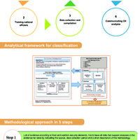
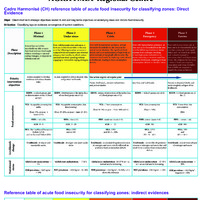
Facing recurrent food and nutrition insecurity affecting Sahelian and West African populations, governments and their development partners have set up mechanisms to monitor food situation. However, these mechanisms do not use the same methodological approaches, which often lead to results that are difficult to compare and which at times are even contradictory. Aware of this situation and the need to find a suitable solution, CILSS member states and partners have initiated the development of a Cadre harmonisé d’identification et d’analyse des zones à risque et des populations en insécurité alimentaire et nutritionnelle au Sahel et en Afrique de l’Ouest (Harmonized Framework for Identification and Analysis of Areas at Risk of and Populations Affected by Food and Nutrition Insecurity in the Sahel and West Africa). This tool, known as “Cadre Harmonisé” (CH), is expected to serve as a framework for countries to assess food and nutrition insecurity on an objective and consensual basis. The purpose of the Cadre Harmonisé is to help countries prevent food crises better and, where appropriate, quickly identify affected populations and appropriate measures to improve their food and nutrition security. The related method has been developed by a group of food and nutrition security experts from CILSS, FAO, WFP, FEWS NET, AFD, IPC/GSU, JRC/EC and UNICEF, and from international NGOs Oxfam International, Save the Children and ACF1. It is worth recalling that starting from 2008, various meetings held by the CH Technical Committee agreed for the CH to include some elements of the Integrated Food Security Phase classification version 1 (IPC 1.0). The IPC is a set of tools and procedures for classifying food and nutrition insecurity severity for decision making. Since the development of a manual for IPC 2.0, discussions have been under way to bring the CH closer to the IPC to incorporate lessons learned that improve comparability of results from the two tools. Similar to the IPC, the Cadre Harmonisé seeks to make best use of a set of tools and procedures for classifying the nature and severity of current and projected food and nutrition insecurity situations on the basis of a consensual analytical framework and classification scale. The CH is based on the following four conceptual models commonly used by national, regional and global mechanisms: Risk = f (Hazard, Vulnerability) Sustainable Livelihoods Framework The UNICEF Nutrition Conceptual Framework The four dimensions of food security (availability, access, utilization, and stability) The CH therefore is an integrated analytical framework built on a technical consensus that seeks to make best use of data from all systems or methods, namely food consumption surveys, nutrition surveys, the Household Economy Approach (HEA) or other information provided by agricultural surveys and market monitoring. The CH assesses food and nutrition insecurity, based on convergence of evidence from several indicators. The CH uses a food insecurity severity scale with five phases. Such a severity scale, which is an international one, makes it possible to make comparisons between countries of the sub-region and also at global level. CILSS was mandated to develop and implement the CH as a common tool for Sahelian and West African countries. Its analysis cycles will from now on help develop regional mapping of current food and nutrition situations and analyze projected situations. 1 Other institutions such as MIFRAC, IBIMET and CARE International initially contributed to the development of the present analytical framework. Cadre Harmonisé MANUAL Version 1.0 Page | 13 The CH also seeks to strengthen the regional integration framework in the CILSS-ECOWAS-UEMOA region so that collaborative and harmonized analyses of food and nutrition situations are conducted through the best possible use of other tools and analysis methods developed by national mechanisms and partners. Given the importance of the process of harmonizing the analytical framework for food and nutrition situations in West Africa, it is necessary that all food and nutrition security stakeholders take ownership of it and make it their decision-making tool. Furthermore, efforts are needed to strengthen the partnership framework within countries and to support the operations of early warning systems in order to improve the collection of reliable data. CH implementation relies on existing data collection mechanisms. Efforts should be made by countries and partners to provide financial support to these mechanisms - as CH implementation will from now on be the baseline reference for activating regional food reserves and mobilizing technical and financial partners (TFPs).
Mapping of zones at risk in west Africa by using NGI, VCI and SNDVI from the E-Station.
This work is carried out at the AGRHYMET Regional Centre (ARC)-CILSS as part of the African Monitoring of Environment for Sustainable Development (AMESD) project. The analysis protocol has been improved under the Monitoring of Environment for Security in Africa (MESA) project. The MESA Project has been designed on the achievements of AMESD; its overall objective is to provide African countries with access to Earth Observation data for environmental monitoring and sustainable development. The specific objective of this study is to develop an operational analysis protocol for vegetation monitoring in general and especially for crops and pastures. Three vegetation indices were used: Vegetation Condition Index (VCI), Normalized Growth Index (NGI) and Standardized Normalized Difference Vegetation Index (SNDVI). The analysis of these drought indices is based on taking into account the agro-climatic characteristics of the Sahelian region, the comparison of the NGI profile (per administrative unit) from year X (in progress) to the maximum NGI profiles, minimum and average of the time series data (1998 to year x-1) and evidence convergence. Six years of application of the method and validation actions carried out concluded that it is possible to determine the zones at risk (ZAR) in order to anticipate food crises.
Seasonal forecast of the agro-hydro-climatic characteristics of the 2017 rainy season for the Sahelo-Soudano countries of CILSS/ECOWAS region
Following the update of the agro-hydro-climatic forecasts made in July 2017, the perspectives for the cumulative rainfall, ending dates of the season and river basins flows for the 2017 season remain broadly unchanged from the conclusions of the Seasonal Forecast Forum held in May 2017 in Accra, Ghana. As for the onset dates of the season and the durations of the longest dry spells during the crop installation phase, they were generally confirmed by the field observations and the analyses at the regional level.
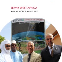
Servir west africa annual work plan – fy 2017
On March 21, 2016, USAID awarded Tetra Tech a five-year contract to support the Agrometeorology, Hydrology and Meteorology Regional Center (AGRHYMET) in the implementation of SERVIR West Africa. The goal of SERVIR West Africa (SERVIR WA) is to increase the ability of institutions across the region to apply geospatial technologies and analysis to improve the region’s resilience to climate change impacts and ensure that land use management reduces greenhouse gas (GHG) emissions. The program supports the Permanent Interstate Committee for Drought Control in the Sahel (CILSS)/AGRHYMET’s ability to increase the supply of geospatial information and knowledge products and services for resilient and low carbon development to member countries in food security and agriculture; water and water-related disasters; land cover and land use change and ecosystems; and weather and climate. To support this goal, SERVIR WA has the following program objectives:
Servir west africa-ppt niger 17 may 2016
Endorsed by USAID and NASA leadership: 1.Reach More Users with Demand-Driven Products and Services 2.Connect More Innovative and Appropriate Science to SERVIR 3.Expand SERVIR Networks through New Strategic Partnerships 4.Improve Sustainability of SERVIR at Multiple Levels
